Posts

Showing posts from November, 2020
Image
When you are between Star and Innerhill islands if you look down, at times you can see what is left of the Stanley. 
Image
Tookers island, well half of it anyway. 
Image
On the way to Lake Richie, a spider. 
Image
From the tower, looking north / northwest, Canada is in the distance with some canadian geese coming over the ridge.
Image
f you are headed to Windigo via the north shore and the water is pretty flat, it is almost a given that you will stop and look at the America.  https://en.wikipedia.org/wiki/SS_America_(1898)
Image
A Sargent Lake cattail. 
Image
Mott in the morning. 
Image
Sauna beach in the Fall. 
Image
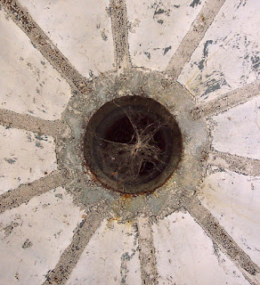
The vent at the top of the Menagerie island lighthouse. (this is the Isle Royale light, not the Rock harbor light that most people see when coming through the Middle island passage) If you made it to Menagerie island and went inside the lighthouse, climbed the stairs and looked straight up, you would see this.  Those old lights used a flame and the gases and heat went up and out.  http://iri.forest.mtu.edu/Lighthouses.htm
Image
Pieces of the Algoma are still showing up on Mott. 
Image
A summer morning at Lake Richie. 
Image
Kayak's at the end of Conglomerate Bay.
Image
Older beaver dam. 
Image
Early Fall, from on top of a Minong mine poor rock pile.
Image
Triangle pond, from right about in the middle of summer. 
Image
Almost to the Menagerie island parking spot.
Image
Gilberts hole. 
Image
Some late spring skunk cabbage. 
Image
A cow and a calf have made it through the winter and found some fresh grass. (From before I had a digital camera.)
Image
Scoville point.